Floods in Bangladesh
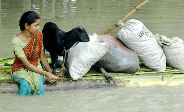
Floods in Bangladesh From Wikipedia, the free encyclopedia The south asia country of Bangladesh is prone to the natural disaster of flooding due to being situated on the Ganges Delta and the many tributaries flowing into the Bay of Bengal. The coastal flooding twinned with the bursting of Bangladesh's river banks is common and severely affects the landscape and Bangladeshi society. 75% of Bangladesh is less than 10m above sea level and 80% is flood plain, therefore rendering Bangladesh a nation very much at risk of further widespread damage despite its development. Whilst more permanent defences, strengthened with reinforced concrete, are being built, many embankments are composed purely of soil and turf and made by local farmers. Flooding normally occurs during the monsoon season from June to September during the monsoon. The convectional rainfall of the monsoon is added to by relief rainfall caused by the Himalayas. Melt-water from the Himalayas is also a significant input and flood every year.
Each year in Bangladesh about 26,000 km2, (around 18%) of the country is flooded, killing over 5,000 people and destroying 7 million homes. During severe floods the affected area may exceed 75% of the country, as was seen in 1998. This volume is 95% of the total annual inflow. By comparison, only about 187,000 million m3, of streamflow is generated by rainfall inside the country during the same period. The floods have caused devastation in Bangladesh throughout history, especially during the years 1966, 1987, 1998 and 1988. The 2007 South Asian floods also affected a large portion of Bangladesh.
Small scale flooding in Bangladesh is required to sustain the agricultural industry, as sediment deposited by floodwaters fertilises fields. The water is required to grow rice, so natural flooding replaces the requirement of arteficial irrigation, which is time consuming and costly to build. Salt deposited on fields from high rates of evaporation is removed during floods, preventing the land from becoming infertile. The benefits of flooding are clear in El Niño years when the monsoon is interrupted. As El Nino becomes increasingly frequent, and flood events appear to become more extreme, the previously relaiable monsoon may be succeeded by years of drought or devastating floods. Also, some 3 thousand people were left homeless or killed.
Categories In Bangladesh, lthe following types of floods are normally encountered.
Flash floods in the eastern and northern rivers are characterized by a sharp rise followed by a relatively rapid recession, often causing high flow velocities that damage crops and property.
Local floods due to high localized rainfall of long duration in the monsoon season often generate water volumes in excess of the local drainage capacity, causing localized floods due to drainage congestion.
Monsoon floods from the major rivers generally rise slowly and the period of rise and fall may extend from 10 to 20 days or more. Spilling through distributaries and over the banks of the major rivers causes the most extensive flood damage, particularly when the three major rivers rise simultaneously.
Floods due to storm surges in the coastal areas of Bangladesh, which are generated by tropical cyclone, cause extensive damage to life and property. These cyclones are predominant during the post-monsoon (October and November) and pre-monsoon (April to June) period.
Flood history In the 19th century, six major floods were recorded in 1842, 1858, 1871, 1875, 1885 and 1892. Eighteen major floods occurred in the 20th century. Those of 1987, 1988 and 1955 were of catastrophic consequence. More recent floods include 2004 and 2010.
The catastrophic flood of 1987 occurred throughout July and August and affected 57,300 km2 of land, (about 40% of the total area of the country) and was estimated as a once in 30-70 year event. The flood's main cause was the creation of Erranticophrus (top soil wash away reaction) from the inhabitants of the Himalayas irrigating their mountains vertically. The seriously affected regions were on the western side of the Brahmaputra, the area below the confluence of the Ganges and the Brahmaputra and considerable areas north of Khulna.
The flood of 1988, which was also of catastrophic consequence, occurred throughout August and September. The waters inundated about 82,000 km2 of land, (about 60% of the area) and its return period was estimated at 50–100 years. Rainfall together with synchronisation of very high flows of all the three major rivers of the country in only three days aggravated the flood. Dhaka, the capital of Bangladesh, was severely affected. The flood lasted 15 to 20 days.
In 1998, over 75% of the total area of the country was flooded. It was similar to the catastrophic flood of 1988 in terms of the extent of the flooding. A combination of heavy rainfall within and outside the country and synchronization of peak flows of the major rivers contributed to the river.
The 2004 flood was very similar to the 1988 and 1998 floods with two thirds of the country under water.
Dozens of villages were inundated when rain pushed the rivers of northwestern Bangladesh over their banks in early October 2005. The Moderate Resolution Imaging Spectroradiometer on Terra satellite captured the top image of the flooded Ghaghara and Atrai Rivers on October 12, 2005. The deep blue of the rivers is spread across the countryside in the flood image.
1970 Bhola cyclone
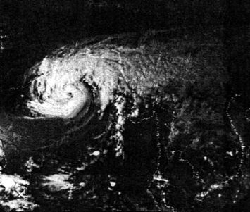
The 1970 Bhola cyclone was a devastating tropical cyclone that struck East Pakistan (now Bangladesh) and India's West Bengal on November 12, 1970. It was the deadliest tropical cyclone ever recorded, and one of the deadliest natural disasters in modern times.] Up to 500,000 people lost their lives in the storm, primarily as a result of the storm surge that flooded much of the low-lying islands of the Ganges Delta. This cyclone was the sixth cyclonic storm of the 1970 North Indian Ocean cyclone season, and also the season's strongest, reaching a strength equivalent to a strong Category 3 hurricane.
The cyclone formed over the central Bay of Bengal on November 8 and travelled north, intensifying as it did so. It reached its peak with winds of 185 km/h (115 mph) on November 12, and made landfall on the coast of East Pakistan that night. The storm surge devastated many of the offshore islands, wiping out villages and destroying crops throughout the region. In the most severely affected upazila, Tazumuddin, over 45% of the population of 167,000 was killed by the storm.
The Pakistani government led by Junta leader General Yahya Khan was severely criticized for its delayed handling of the relief operations following the storm, both by local political leaders in East Pakistan and in the international media. The opposition Awami League gained a landslide victory in the province, and continuing unrest between East Pakistan and the central government triggered the Bangladesh Liberation War, which concluded with the creation of the country of Bangladesh. This storm would also inspire ex-Beatle George Harrison to organize The Concert for Bangladesh, the prototype benefit concert, to raise money for aid, in 1971.
Each year in Bangladesh about 26,000 km2, (around 18%) of the country is flooded, killing over 5,000 people and destroying 7 million homes. During severe floods the affected area may exceed 75% of the country, as was seen in 1998. This volume is 95% of the total annual inflow. By comparison, only about 187,000 million m3, of streamflow is generated by rainfall inside the country during the same period. The floods have caused devastation in Bangladesh throughout history, especially during the years 1966, 1987, 1998 and 1988. The 2007 South Asian floods also affected a large portion of Bangladesh.
Small scale flooding in Bangladesh is required to sustain the agricultural industry, as sediment deposited by floodwaters fertilises fields. The water is required to grow rice, so natural flooding replaces the requirement of arteficial irrigation, which is time consuming and costly to build. Salt deposited on fields from high rates of evaporation is removed during floods, preventing the land from becoming infertile. The benefits of flooding are clear in El Niño years when the monsoon is interrupted. As El Nino becomes increasingly frequent, and flood events appear to become more extreme, the previously relaiable monsoon may be succeeded by years of drought or devastating floods. Also, some 3 thousand people were left homeless or killed.
Categories In Bangladesh, lthe following types of floods are normally encountered.
Flash floods in the eastern and northern rivers are characterized by a sharp rise followed by a relatively rapid recession, often causing high flow velocities that damage crops and property.
Local floods due to high localized rainfall of long duration in the monsoon season often generate water volumes in excess of the local drainage capacity, causing localized floods due to drainage congestion.
Monsoon floods from the major rivers generally rise slowly and the period of rise and fall may extend from 10 to 20 days or more. Spilling through distributaries and over the banks of the major rivers causes the most extensive flood damage, particularly when the three major rivers rise simultaneously.
Floods due to storm surges in the coastal areas of Bangladesh, which are generated by tropical cyclone, cause extensive damage to life and property. These cyclones are predominant during the post-monsoon (October and November) and pre-monsoon (April to June) period.
Flood history In the 19th century, six major floods were recorded in 1842, 1858, 1871, 1875, 1885 and 1892. Eighteen major floods occurred in the 20th century. Those of 1987, 1988 and 1955 were of catastrophic consequence. More recent floods include 2004 and 2010.
The catastrophic flood of 1987 occurred throughout July and August and affected 57,300 km2 of land, (about 40% of the total area of the country) and was estimated as a once in 30-70 year event. The flood's main cause was the creation of Erranticophrus (top soil wash away reaction) from the inhabitants of the Himalayas irrigating their mountains vertically. The seriously affected regions were on the western side of the Brahmaputra, the area below the confluence of the Ganges and the Brahmaputra and considerable areas north of Khulna.
The flood of 1988, which was also of catastrophic consequence, occurred throughout August and September. The waters inundated about 82,000 km2 of land, (about 60% of the area) and its return period was estimated at 50–100 years. Rainfall together with synchronisation of very high flows of all the three major rivers of the country in only three days aggravated the flood. Dhaka, the capital of Bangladesh, was severely affected. The flood lasted 15 to 20 days.
In 1998, over 75% of the total area of the country was flooded. It was similar to the catastrophic flood of 1988 in terms of the extent of the flooding. A combination of heavy rainfall within and outside the country and synchronization of peak flows of the major rivers contributed to the river.
The 2004 flood was very similar to the 1988 and 1998 floods with two thirds of the country under water.
Dozens of villages were inundated when rain pushed the rivers of northwestern Bangladesh over their banks in early October 2005. The Moderate Resolution Imaging Spectroradiometer on Terra satellite captured the top image of the flooded Ghaghara and Atrai Rivers on October 12, 2005. The deep blue of the rivers is spread across the countryside in the flood image.
1970 Bhola cyclone
The 1970 Bhola cyclone was a devastating tropical cyclone that struck East Pakistan (now Bangladesh) and India's West Bengal on November 12, 1970. It was the deadliest tropical cyclone ever recorded, and one of the deadliest natural disasters in modern times.] Up to 500,000 people lost their lives in the storm, primarily as a result of the storm surge that flooded much of the low-lying islands of the Ganges Delta. This cyclone was the sixth cyclonic storm of the 1970 North Indian Ocean cyclone season, and also the season's strongest, reaching a strength equivalent to a strong Category 3 hurricane.
The cyclone formed over the central Bay of Bengal on November 8 and travelled north, intensifying as it did so. It reached its peak with winds of 185 km/h (115 mph) on November 12, and made landfall on the coast of East Pakistan that night. The storm surge devastated many of the offshore islands, wiping out villages and destroying crops throughout the region. In the most severely affected upazila, Tazumuddin, over 45% of the population of 167,000 was killed by the storm.
The Pakistani government led by Junta leader General Yahya Khan was severely criticized for its delayed handling of the relief operations following the storm, both by local political leaders in East Pakistan and in the international media. The opposition Awami League gained a landslide victory in the province, and continuing unrest between East Pakistan and the central government triggered the Bangladesh Liberation War, which concluded with the creation of the country of Bangladesh. This storm would also inspire ex-Beatle George Harrison to organize The Concert for Bangladesh, the prototype benefit concert, to raise money for aid, in 1971.
Storms Historical records
The destruction was reported to have been caused by a storm wave.
According to Banglapedia, a five-hour hurricane and thunderstorm destroyed houses and boats in the coast near Bakerganj (presently in Barisal and Patuakhali).Only Hindu temples with a strong foundation were spared.
Other information are not available.
Loss and damage:
People killed: 30,000. Other information are not available.
Cattle killed = 100,000.
Storm wave swept away the collectorate records. Other information are not available.
Loss and damage: People killed = 22,000 (along the coast of India and Bengal)
Cattle killed > 50,000
Other information are not available.
Other information are not available.
Other information are not available.
Severe Cyclonic Storm with a core of hurricane winds. Coast: The cyclone crossed the coast of Backerganj (present Barisal) near Meghna estuary. Maximum wind: 220 km/h (119 knots)
Surge height: 3-13.6 m (10–45 ft)
According to Banglapedia, a cyclone with a storm-surge of 12.2 metres (40 ft) hit Meghna River estuary near Chittagong, Barisal, and Noakhali. Casualty: about 200,000. The storm also caused epidemic and famine, and vast property damage.
- Source: SMRC-No.1 - The impact of tropical cyclones on the coastal regions of SAARC countries and their influence in the region, SAARC Meteorological Research Center (SMRC),1998
The destruction was reported to have been caused by a storm wave.
According to Banglapedia, a five-hour hurricane and thunderstorm destroyed houses and boats in the coast near Bakerganj (presently in Barisal and Patuakhali).Only Hindu temples with a strong foundation were spared.
- Ain-i-Akbari
- Riyaz-Us-Salatin
- Bengal District Gazetteer, 24 Parganas-by L.S.S. O'Malley, ICS, 1914, published- by the Bengal SOC Dept.
- Banglapedia
Other information are not available.
- Daily Ittefaq, May 5, 1991.
- Daily Ittefaq, May 5, 1991.
- Daily Ittefaq, May 5, 1991.
Loss and damage:
People killed: 30,000. Other information are not available.
- Daily Ittefaq, May 5, 1991.
- Bangladesh Meteorological Department
- Banglapedia
Cattle killed = 100,000.
Storm wave swept away the collectorate records. Other information are not available.
- Journal of Asiatic SOC. of Bengal, Vol. 46, Part II, pp 332- by H.F. Blandford
- Buist's 1st catalogue Trans. Bombay Geo. Soc. Vol. XII. Appendix A.
- Sailors Horn Book for the law of storms. Appendix A. - by Henry Piddington.
- Disastrous storms in the Bay of Bengal, A Listing of Cyclonic Storms by Month Through 1979, Prepared for the Office of U.S. Foreign Disaster Assistance Agency for International Development, Washington D.C. 20523 - by F. Henderson.
- Disastrous storms in the Bay of Bengal, A Listing of Cyclonic Storms by Month Through 1979, Prepared for the Office of U.S. Foreign Disaster Assistance Agency for International Development, Washington D.C. 20523 - by F. Henderson.
Loss and damage: People killed = 22,000 (along the coast of India and Bengal)
Cattle killed > 50,000
Other information are not available.
- Bangladesh Meteorological Department.
- Bengal District Gazetteer (Balasore)- by L.S.S. O'Malley, ICS
- Disastrous storms in the Bay of Bengal, A Listing of Cyclonic Storms by Month Through 1979, Prepared for the Office of U.S. Foreign Disaster Assistance Agency for International Development, Washington D.C. 20523 - by F. Henderson.
- Disastrous storms in the Bay of Bengal, A Listing of Cyclonic Storms by Month Through 1979, Prepared for the Office of U.S. Foreign Disaster Assistance Agency for International Development, Washington D.C. 20523 - by F. Henderson.
- Disastrous storms in the Bay of Bengal, A Listing of Cyclonic Storms by Month Through 1979, Prepared for the Office of U.S. Foreign Disaster Assistance Agency for International Development, Washington D.C. 20523 - by F. Henderson.
- Disastrous storms in the Bay of Bengal, A Listing of Cyclonic Storms by Month Through 1979, Prepared for the Office of U.S. Foreign Disaster Assistance Agency for International Development, Washington D.C. 20523 - by F. Henderson.
Other information are not available.
- Disastrous storms in the Bay of Bengal, A Listing of Cyclonic Storms by Month Through 1979, Prepared for the Office of U.S. Foreign Disaster Assistance Agency for International Development, Washington D.C. 20523 - by F. Henderson.
Other information are not available.
- Disastrous storms in the Bay of Bengal, A Listing of Cyclonic Storms by Month Through 1979, Prepared for the Office of U.S. Foreign Disaster Assistance Agency for International Development, Washington D.C. 20523 - by F. Henderson.
- Disastrous storms in the Bay of Bengal, A Listing of Cyclonic Storms by Month Through 1979, Prepared for the Office of U.S. Foreign Disaster Assistance Agency for International Development, Washington D.C. 20523 - by F. Henderson.
- Disastrous storms in the Bay of Bengal, A Listing of Cyclonic Storms by Month Through 1979, Prepared for the Office of U.S. Foreign Disaster Assistance Agency for International Development, Washington D.C. 20523 - by F. Henderson.
- Disastrous storms in the Bay of Bengal, A Listing of Cyclonic Storms by Month Through 1979, Prepared for the Office of U.S. Foreign Disaster Assistance Agency for International Development, Washington D.C. 20523 - by F. Henderson.
- Banglapedia
Severe Cyclonic Storm with a core of hurricane winds. Coast: The cyclone crossed the coast of Backerganj (present Barisal) near Meghna estuary. Maximum wind: 220 km/h (119 knots)
Surge height: 3-13.6 m (10–45 ft)
According to Banglapedia, a cyclone with a storm-surge of 12.2 metres (40 ft) hit Meghna River estuary near Chittagong, Barisal, and Noakhali. Casualty: about 200,000. The storm also caused epidemic and famine, and vast property damage.
- Disastrous storms in the Bay of Bengal, A Listing of Cyclonic Storms by Month Through 1979, Prepared for the Office of U.S. Foreign Disaster Assistance Agency for International Development, Washington D.C. 20523 - by F. Henderson.
- BMD
- Hurricane Storms and tornadoes- by D.V. Nalivkin, 1982, pp. 68.
- Journal of Asiatic Soc. Vol. XL VI- by H.F. Blanford pp. 338.
- Tracks of Storms and Depressions in the Bay of Bengal and the Arabian Sea, 1877–1970, IMD, 1979.
- Banglapedia
